


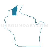
KEYSTONE - T 1 Voting District, Bayfield County, Wisconsin
About
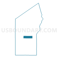
Outline

Summary
| Unique Area Identifier | 692346 |
| Name | KEYSTONE - T 1 Voting District |
| County | Bayfield County |
| State | Wisconsin |
| Area (square miles) | 36.05 |
| Land Area (square miles) | 35.78 |
| Water Area (square miles) | 0.27 |
| % of Land Area | 99.25 |
| % of Water Area | 0.75 |
| Latitude of the Internal Point | 46.52321870 |
| Longtitude of the Internal Point | -91.18944150 |
Maps

Graphs
Select a template below for downloading or customizing gragh for KEYSTONE - T 1 Voting District, Bayfield County, Wisconsin


Neighbors
Neighoring Voting District (by Name) Neighboring Voting District on the Map
- DELTA - T 1 Voting District, Bayfield County, WI
- EILEEN - T 1 Voting District, Bayfield County, WI
- EILEEN - T 2 Voting District, Bayfield County, WI
- IRON RIVER - T 1 Voting District, Bayfield County, WI
- MASON - T 1 Voting District, Bayfield County, WI
- PILSEN - T 1 Voting District, Bayfield County, WI
Top 10 Neighboring County Subdivision (by Population) Neighboring County Subdivision on the Map
- Iron River town, Bayfield County, WI (1,123)
- Eileen town, Bayfield County, WI (681)
- Keystone town, Bayfield County, WI (378)
- Mason town, Bayfield County, WI (315)
- Delta town, Bayfield County, WI (273)
- Pilsen town, Bayfield County, WI (210)
Top 10 Neighboring Unified School District (by Population) Neighboring Unified School District on the Map
- Ashland School District, WI (12,503)
- Maple School District, WI (7,983)
- Drummond Area School District, WI (4,580)